|
| |
This story courtesy of Robb Pennie and Vern Pennie
|
| Mother Nature's Sense of Humor
I was sure that I was getting the other end of the raw deal that I'd
driven out of a week earlier. The prior Sunday, sweeping six inches of snow
off the car, I'd left Crested Butte in a blinding snow storm at five a.m.
The plows had made a couple of passes through the darkness, but the roads
were terrible, not drying out until Montrose. Though I could see that the
dirt bike was still intact on the trailer when I turned on the rear wiper,
that little voice in my head was hollering that I should have staid in CB
for the powder day, that I'd never drive out of this storm, that my endeavor
to get somewhere where there was dirt and sun and warmth would be for naught.
But by the time I turned south off I-70 for the Ruby Ranch dunes, the windows
were down with warm air blasting the winter away from me. It was a completely
different world than the place I had escaped from just hours before.
Now, a week later, it seemed that winter had found me even in the deserts
of Utah. Turning south off interstate, the landscape should have been a
heat-induced shimmering of deep reds and browns. But on that 20th of March,
it was pasted white with two inches of new snow. I shook my head at Mother
Nature's irony, allowing me to revisit what I ran from the week before.
Dad, who drove 1500 miles from Minnesota, didn't know what to think either.
With that kind of mileage behind him, we weren't about to sit in the Green
River Comfort Inn and wait for it to melt. So we pushed south down the Floy
Road for the dunes.
Ruby Ranch Dunes
Ten miles south of I-70 at exit #273, being careful to turn right at
the abandoned oil well and left at the derelict tanker trailer, you'll find
dunes. Some people refer to them as the Dubinky Dunes, some as the Corral
Dunes, and others call them the Ruby Ranch Dunes. Blocked in by the White
Wash on one side and walls of red rock on the other, the Ruby Ranch dunes
is a scraggly little sandbox, just a touch bigger than the Little Sahara
dunes in Oklahoma. They stretch three or four miles in length, wrapping
around a red-rock monolith before dead-ending near the top of the White
Wash on the south eastern side and trickling out at the Ruby Ranch fence
on the western edge. If you can't blast them end-to-end in an hour, it's
probably because you're on your kid's Breeze.
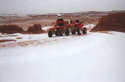
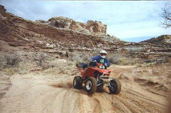
On this chilled, gray day, traction was not an issue. With an inch of
snow rapidly melting and wetting the sand, my mom's poorly shod Fourtrax
300EX was hooking up and climbing like a 250R with paddles. Okay, maybe
not quite like an R, but at least as good as a Banshee. The fifty-foot-tall
dunes made the little quad look like a super-star.
While the dunes don't offer a lot in terms of challenge and variety,
there were a couple of good climbing dunes, a couple of good jumping dunes,
and a couple of pseudo-bowls to rip around in. There aren't lava rocks to
worry about slamming into at the bottom of the dunes, but this sand box
is laced with slick rock. If you blow it and have to ride the rocks, it
could actually be kind of fun on the grippie, smooth stuff.
Exploration
We explored the dunes west to east, looping around the big redrock mountain
in the middle of the area. If you're into riding slickrock, you can get
up on the big outcropping and test your technical riding skills. If you're
afraid of tipping over and bashing your machine to pieces, you'll be just
fine in the sand. We had fun cruising the little dunes and sand trails,
stopping to take in the impressive sand stacked right up against the slickrock.
From the redrock mountain, we worked our way west, toward the Ruby Ranch
fence. When we ran out of connected dunes, we opted for the White Wash and
sixth gear. Sand washes and ATVs--you gotta love them. This wash was smooth,
with only a small stream running down one side, so it was make-like-a-low-flying-aircraft
time.
At the Ruby Ranch fence, we turned left and followed a whooped out trail
south until the Red Wash Trail took off the left and our trail kept going
straight. We opted to keep going straight along the fence.
Red Wash
We parted from the fence when we came to a spur of the Red Wash, carved
deep into the slick rock. After scouting around a bit, we found a feasable
place to drop in for further exploration. Working our way down a couple
of slick rock drops, we went through a gate in the fence we'd been paralleling
earlier. From there, we wandered through some different branches of the
wash, being stopped by a fence line without a gate on the western end and
having to turn around when we were closed-out near the top of the wash on
the eastern end. It was interesting exploring the red-rock channels, but
not so much fun that we'd go back and ride it again for kicks. It didn't
really open up enough to get rolling in or continue in any one direction
long enough to get the thumbs up.
Eventually we backtracked out of the wash and headed back along the fence
line for the Red Wash Trail. Once there we turned on to grated trail and
headed east.
After following the Red Wash Trail for a couple of miles (it gradually
begins swinging from the east to the south), we came to another section
of the Red Wash that begged to be explored. We headed upstream on smooth
sand, able to hit fourth and fifth gear in some sections. We explored a
couple of tributaries--they tended to be total slick rock, complete with
rock steps that took a little studying to climb cleanly. Dropping the steps
were a hoot on the return. While Dad tended to ease down them, I was more
into the hit-it-in-second, launch and let-the-suspension-do-it's-job scene.
We both had fun. Within a half-hour of turning into this section of the
Red, we explored just about all the options and headed back out. The downstream
option looking like it might be promising, but quickly dead-ended at a waterfall.
We returned to the Red Wash Trail and continued to follow it east and
south. After going through a gate, the trail seemed to disappear onto a
large field of slick rock. On our first attempt, we lost the trail, heading
where we thought it was going and then finding nothing. On our next try,
we made an effort to go straight across all of the rock and found the trail
again on the other side.
From the edge of the rock, we rode another five miles, looking for the
Ten Mile Wash, but didn't have any luck. By that time, we were on the Duma
Point Road and had missed our unmarked turn-off. Though the snow had let
up when we started our ride earlier in the day, it had been coming down
pretty good for the past hour. We'd managed to stay dry throughout the morning
in the sand, the high speeds on the road had us catching a lot more snow,
getting cold and wet. We gave up on Ten Mile for the day and headed back.
Though the 300EX is pretty easy on the gas, I hit reserve about ten miles
from the truck (Dad's 400EX was sucking from the bottom of the tank, too),
so using our Honda gas consumption computer, we know we logged around sixty
miles, total.
|
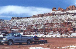
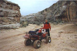
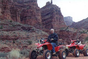
Headlights glazed over with frozen mud--good
omen, or bad?
See the
Map further down
the page . . . |
|
It wasn't to be the prettiest day to ride,
but when you're on the road for days just to get there, you can't be picky.
|
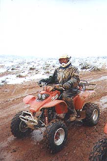
We were hoping the spring conditions around Moab would be
a little more, well, springlike.
|
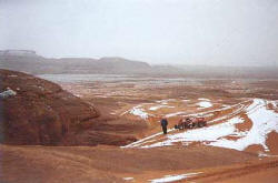
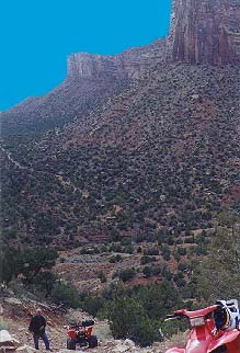
Redrock, dunes and snow all in one picture. Only in Utah
. . .
|
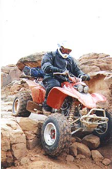
One method of shining up your skid-plate's as good as another.
This was about the smallest rock step on the ride.
|
I laughed pretty hard at Dad for having red ice caked all
over him--figured he was riding too slow or something. Then I noticed how
stiff the front of my jacket was and looked down . . .
|
|
| Gold Bar Rim
The next morning found us at the Gold Bar Rim/Gemini Bridges trailhead,
about nine miles north of Moab on highway 191. It appeared to have snowed
there through the night. The deep reds and browns that usually paint the
the canyon landscape were almost completely hidden by a two-inch frosting
of white. With the sun barely breaking through the wall of clouds obscuring
the LaSalle mountains to the southeast and a crisp breeze to fully chillily
the mid-30-degree morning, we headed for the Gold Bar Rim.
The trail takes off to the south on a railroad grade for the first mile,
then climbs up the red rock bluff before dropping into a high canyon further
south. Staying on the sandy main trail brought us to a fork in the road
with a sign offering the options of either the Gold Bar Rim or Gemini Bridges
trails. The Gemini Bridges themselves, twin arches at the end of a long
wash, were pretty cool, but the trail there is a yawner. The Gold Bar Rim
trail puts you at the top of the massive rock bluffs overlooking Hwy. 191.
Not only is the view staggering, but the trail to get there is a technical
hoot. While not extreme by any means, there are several rock steps that
require either four wheel drive and good ground clearance or a skilled,
confident pilot and a machine with a skid plate.
The rocks covered with black tire marks and oil spots warn of what happens
if you don't have it together for ascending these obstacles. We found that
shorter wheelbase and lower geared 300EX was preferable to the tall first
gear of the 400EX for negotiating these places. A 4x4 with soft suspension
and a granny gear would have been even better yet, but we had fun following
the cairns up the slick rock to the top of the rim.
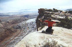
Trying to describe the staggering view from the top of the Gold Bar Rim
is pretty futile. The rocks along the very edge were solid, so a good rush
was to be had by crawling out on my belly to look over the edge. Whew! It
was about 1000 feet straight down, even further to the highway below. After
verifying that it was extremely unlikely that there were any live creatures
down there, I even did the rock-huck test. Major hang time for the projectiles,
with their falls ending as they were pulverized into dust at the base of
the bluff. Very cool stuff.
The ride back to the trail head is a backtrack--the entire ride was a
three or three-and-half-hour endeavor.
|
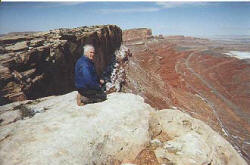
Sights from the Gold Bar Rim ride.
Prepping to ride against a snowy, redrock dropback, just off of Utah Hwy
191 at the trail head (below) and taking in some impressive scenery (left).
 |
|
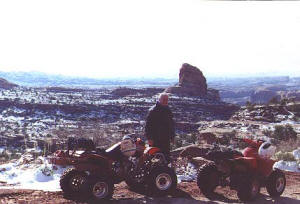
Looking north from atop the Gold Bar Rim. Utah highway
191 is running north-south at the bottom of the bluff.
|
We'd run out of spit at this point, so I started using rocks.
|
|
| Ten Mile Wash
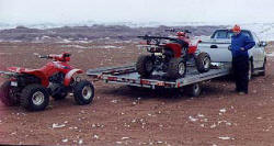
Back at the truck, we loaded up the wheelers and headed for the second
part of the days ride, Ten Mile Wash. Aptly named, Ten Mile is at least
ten miles as it winds its way through bleached slickrock canyons to the
Green River.
To access the wash, we took the Blue Hills Road northwest from Hwy. 191
just south of the Canyonlands airport. After driving on it for a few miles,
we came to an intersection with a rusted out barrel on the right and a smaller
road heading to the west. This was the Levi Road, but was unmarked except
for the barrel. From our last riding trip in the area, Dad remembered it
as being the place to turn to easily access the wash, so we pulled over
and unloaded. On ATVs, we followed Levi Road west, traversing below red
rock buttes on either side of us. After going through a gate and passing
some dunes to our north, then crossing through a smallish wash, we found
back in Ten Mile. Once in the wash we headed to the west--downstream.
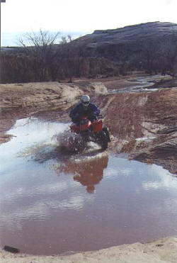
I had been looking forward to really ripping through the sandy wash on
the 300EX, but was a little dismayed to find that there was a pretty good
creek running through it. Though there were areas where we didn't cross
the creek for several hundred yards, we found ourselves on the brakes more
than we would have liked to because of the water. Keep in mind that it was
a 45 degree day and the idea of having to ride wet for a couple of hours
was anything but appealing. Show me the same creek in the same wash on a
warm day and I'll show you one silly, wet rider.
Wash This
Once you get into the wash and go a quarter mile, you'll come to a fence.
Rather than going through the fence, we stuck to the trail running out of
the north side of the wash. This led us to a gate and easy access to the
rest of the wash. Back in the wash it was fast and fun trying to pick the
least wet, least whooped-out sections of trail to ride on. There didn't
seem to be any rule as to which side of wash to stick to and it didn't seem
to matter if we were on the inside or the outside of the turns. Sometimes
we ran out of trail and were riding in the creek, sometimes we were riding
on fun, bermed little trails or flat, smooth sand. The further we rode into
the wash the higher and more red the rock became.
After riding in the wash for an hour we came to another gate--probably
half way down the wash. At the gate, we met a guy on a YZF426 who said that
it was just a couple more miles to the Green River. We took off thinking
that around any corner we'd find the Green and be ready to turn around.
The guy must have been distance perception impaired.
A couple of miles after the fence, with the wash getting deeper and more
narrow, we found it harder and harder to not ride in the stream. Finally,
we were out of other options. The only route was down the three-inch-deep
creek, through a swath of trees not much wider than our machines. If this
were a creek bed anywhere else, I would have opted to save it for a dry
day. Running any wheeled vehicle through creek or streambeds is a good way
to do some serious damage to it. But the bottom was solid and the stream
full of silt to begin with, so we rode on.
The creek bed turned to slickrock again, with the creek dropping through
some rapids. We were able to find a way through the rapids, but it was pretty
tight. Continuing on, we rode through another mile of water before the wash
began to open up and the creek disappeared into the sand. I was into sixth
gear quick, charging for the river.
After riding the Ten Mile wash for what seemed like 20 miles, watching
the rock rise to some 200 feet on either side of us, it finally opened up
to show us the Green. Though we were psyched to be there, we were kind of
amazed that it had taken over three hours from the truck to do so. After
testing the echo effect in the canyon and taking couple of pictures to prove
that we were there, we reversed course, backtracking our way out of the
wash. It didn't seem quite as long coming back, but riding through and across
all the water made it a long one.
 Back
at the upstream end of the wash and the intersection of road that we came
in on, we headed north out of the wash, instead backtracking south the way
we came. From there we connected some roads together on our way to the truck,
putting another ten or fifteen miles on the day's ride. Back
at the upstream end of the wash and the intersection of road that we came
in on, we headed north out of the wash, instead backtracking south the way
we came. From there we connected some roads together on our way to the truck,
putting another ten or fifteen miles on the day's ride.
We were loaded up around five, cooking dinner on the end gate and enjoying
what was turning into a comfortably warm evening. Mother Nature served up
a beautiful sunset to do the dishes by and we were back in Green River just
after dark.
|
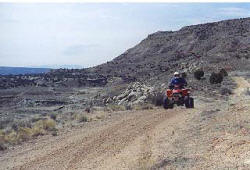
The open, dry part of the wash.
|
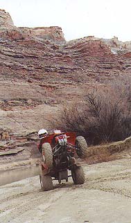
Vern doin' the turn-&-burn.
|
Climbing the falls at the top of Tenmile wash.
|
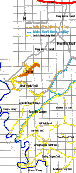
You'd be nuts if you tried to navigate by this map. Rather
swing by the Moab visitor center and pick up some more detailed cartogrophy,
like the "Recreation Map of the Moab Area and Canyon Country Vicinity" by
F.A. Barnes. The six bucks you spend on it will pay off in spaids!
|
|
| Exploring Kokopelli
Onion Creek
On the first day of our ride, Dad and I were looking for something that
neither of us had ridden. I heard from a Crested Butte mountain man that
Onion Creek, north and east of Moab on hwy. 128, was a beautiful little
canyon to camp in. Our map showed that there were trails branching off of
the Onion Creek Trail, so we checked it out. After turning off of 128 and
driving a mile or so in to park, we unloaded and started up the canyon.
We'd read in a Jim Scharf article in DIRT WHEELS that there were over a
dozen water crossings on the road, but we figured that was just because
he was there during a monsoon. What do ya know--ol' Jimmy was right. It
wasn't as crazy as Ten Mile, but we were in and out of the water 17 times--enough
to coat the fenders with red sand.
The trade-off for the numerous fjords was a redrock canyon that looked
as though it had been constructed by a giant kid making red rock drip castles.
The road wound through the canyon, staying relatively smooth and easy--nothing
I would think twice about driving the family roadster through. Once through
the tightest part of the canyon, the road begins climbing up to the Fisher
Valley. Just after we climbed up to the valley floor, we went through a
gate and opted to turn left and go north west up the Cottonwood Canyon Trail.
Cottonwood Canyon Trail
The Cottonwood Canyon Trail is part of the Kokopelli trail that runs
from Grand Junction, Colorado, to Moab. From what I know of it, the trail
consist primarily of jeep road, which we found the Cottonwood trail to be.
For the most part, it was sandy, then rocky double track, with small washes
crossing it. The trick was to go slow enough to handle the obstacles in
the road and be able to look around high bluffs and canyon that the trail
was cutting between.
The most challenging part of the ride was the ravine encountered about
four miles out the Cottonwood Canyon trail. Getting in was no big deal,
dropping a couple hundred feet down relatively good jeep road. The other
side was pretty hairball, though. It was rough and steep to begin with,
then became infested with rocks and slabbed rock steps. I clawed over a
couple, but lost my line at the third and had to stop. Dad was behind me
and decided to stop one step below me. Problem was, he stalled the 400,
left the clutch out and didn't get to the front brakes fast enough. Before
he could recover, the front end was in the air, helping him do some tumbling
maneuvers off the backend. No major damage to man or machine, but the hill
was steep enough so that there was no room for error.
After looking at it for a while, I found a line and horsed the 300 up
the last two steps to the top. It wasn't pretty, but there were no clanging
noises from rock/quad contact. The top offered views in the Cottonwood Canyon,
some two- or three-hundred feet deep at this point. There was a gate at
the top that I went through and explored on ahead a mile or so. I was more
interested in whether the trail looked dirt-bikeable for a future all-out
Kokopelli trail overnight ride. There were a couple more technical short
ascents in that mile, but nothing like what we'd just encountered. Satisfied
that the wife and I could work through the couple of tricky sections with
the wife on a future ride, I turned back.
Back-tracking along the Cottonwood trail and Onion Creek Road had us
back to the truck and supper on the end gate in an hour or two.
Skunked at Rabbit Valley
On our last day of riding, we decided to check out the Rabbit Valley
area just off of I-70 in Colorado. What we found at the last exit heading
west to Utah, is a torn up OHV area that the BLM is making extensive efforts
to rejuvenate. I have to hand it to the government for trying to fix it
rather than just closing it, but the place just didn't have a good feel.
From what we saw, if you have any other places that you're thinking about
exploring, check them out first. Lots of trail closed signs and other restrictions.
The Kokopelli trail running through the area attracted me to it. To make
a long story short, there was much better riding in Moab, but we worked
the ATV-legal Koko trail for three or four hours, heading west for an out-and-back
ride. We saw some good views, banged the skid plates on some rocks and had
an alright time. But if you've got the cruise set, the air conditioning
on and your favorite song comes on the radio, you'd be crazy to turn off
the freeway to ride there.
Logistics
There are plenty of motels and camping options around
Moab, so whether you're looking to rough
it or are into air conditioning, they'll have something for you. Riding
season varies from year to year, but is usually good from the end of March
through October. With temps in the 100s, it's a little nutty to be out there
riding in the summer--fall and spring are preferable. Take a quick look
at the current
Moab weather
if you'd like. If you have other questions about the area,
email me and check out the
above links. Be prepared when ever going into the desert. Water, snacks
& sunblock are a good start. When looking around the Moab website, be sure
to check out their "be prepared" area.
Tread Lightly
While we were in Utah riding, a part of the San Rafael swell was closed
down to OHV use. The BLM felt that the area was being used and abused by
too many careless people. Not only did we lose a place to ride, but we further
showed that we can't regulate ourselves and take care of our riding areas.
I'm not going to lecture on not unnecessarily tearing up our riding areas,
but do us all a favor and take the time to hit these links (UTMA,
Blue
Ribbon Coalition ) and write a letter that might help persuade the powers
that be from shutting down more areas. Thanks!
|
 The Cottonwood steeps, where Dad's 400EX picked up it's first top-o'-the-bar
scratches. You can see the road dropping in on the other side. And you gotta
love those Southwestern blue skies. Scary what clicking the wrong thing
in photoshop will leave you with.
The Cottonwood steeps, where Dad's 400EX picked up it's first top-o'-the-bar
scratches. You can see the road dropping in on the other side. And you gotta
love those Southwestern blue skies. Scary what clicking the wrong thing
in photoshop will leave you with. |
Where'd all the great views go? Oh yeah, we're riding at Rabbit Valley--there
aren't any.
|
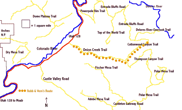
Again, please don't navigate by this map.
But with all the yellow lines being trails, you can see that you'll be saddle-sore
before you run out of trail.

|
|
| |
 |
|
|
| |
|
|
| |
 |
|
| |
 |
|
| |
 |
|
| |
NEW "Paiute
ATV Trail Guide Book". Page
after page of detailed information on the Paiute
ATV Trails. Photos, Maps, GPS Data for every
intersection and point of interest on the trail,
Tip and Tricks for riding the Paiute ATV Trails.
Click Here for More details. |
|
|
|
 |
|
|
|
 |
|
| |
|
|
|
|
Trails Illustrated topographic maps are designed
to take you into the wilderness and back.
Printed on durable tear-resistant, waterproof
material, this map can go virtually anywhere you
do!
Click here for details. |
|
| |
|
|
|
|
Sponsors
Needed |
|
|
|
Your Ad
Can Go Here! |
|
|
|
Contact Us
Click Here
to request
Details. |
|
|
|
Multiple
Website
Advertising
Special. |
|
|
|
Buy 1 Banner
and |
|
|
|
Get Advertising
on Multiple Websites.
for one low single
ad price. |
|
|
|
| |
|