|
| |
 Grand
Adventure in Utah Summer 2006 Grand
Adventure in Utah Summer 2006
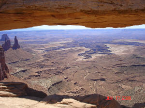
By: Cheryle YoungUtah is HOT in June, but the scenery is astounding,
spectacular in fact. Some say it rivals the Grand Canyon. I
haven't seen the Grand Canyon in person yet, but from the pictures I've
viewed, I agree. What is really unique about the Moab area are the
things people do right amongst the canyons, mesas, and buttes. If you are
thinking ATVing and 4-wheeling you guessed right! In fact, it was so much
fun riding that we barely noticed the temperatures rising to over 100 degrees
each day.
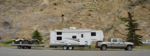 We
hauled what has now been dubbed, “The Road Train”, from Minnesota through
the Rocky Mountains to Moab, Utah. The road train consists of a Silverado
2500 HD Crew Cab truck, a 27’ Cherokee Lite 5th wheel camper and a 16’ double
wide Floe flatbed trailer. The Floe trailer carried 4 ATVs. We
hauled what has now been dubbed, “The Road Train”, from Minnesota through
the Rocky Mountains to Moab, Utah. The road train consists of a Silverado
2500 HD Crew Cab truck, a 27’ Cherokee Lite 5th wheel camper and a 16’ double
wide Floe flatbed trailer. The Floe trailer carried 4 ATVs.
We stayed at a campground called Arch View Resort, located 9 miles north
of Moab, which we highly recommend. Very quiet, easy to maneuver the “Road
Train” and it had a swimming pool, which the kids loved. At the campground
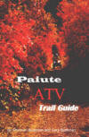
while checking in we found a book called, ATV Trails Guide, Moab UT by Charles
A. Wells. This proved to be a most valuable purchase during this trip. This
book lists 30 trails, with 31 maps, 195 color photos, GPS waypoints and
very vivid descriptions of the trails; whether it was easy, moderate or
difficult, including directions to the trail head. Since we were there on
our own, and had never ridden there before, we were able to have our adventures
without worry.
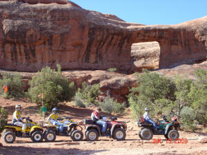
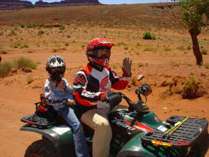 Our
1st day of riding we rode ATV’s on the Potash Road, which is just outside
Cayonlands National Park and below Dead Horse Point State Park. This maintained
trail was a very easy ride. We chose easy trails to ride since we had our
kids riding with us. Our sons, Jake and Zach, each had their own ATV. Our
daughter Bailey rode behind Dad. As I look back, I cannot help but remember,
with awe, how outstanding the scenery was; the red rock and vast canyons
that seemed to go on forever. On this ride, we started out at the same level
as Colorado River and after a few miles we saw it from high vantage points.
The trail wound up on a 'shelf'. The shelf ranged from about 50' to several
hundred feet wide. Our
1st day of riding we rode ATV’s on the Potash Road, which is just outside
Cayonlands National Park and below Dead Horse Point State Park. This maintained
trail was a very easy ride. We chose easy trails to ride since we had our
kids riding with us. Our sons, Jake and Zach, each had their own ATV. Our
daughter Bailey rode behind Dad. As I look back, I cannot help but remember,
with awe, how outstanding the scenery was; the red rock and vast canyons
that seemed to go on forever. On this ride, we started out at the same level
as Colorado River and after a few miles we saw it from high vantage points.
The trail wound up on a 'shelf'. The shelf ranged from about 50' to several
hundred feet wide.
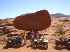 We
rode past a large balanced rock, right next to salt mine lakes that we saw
from above at an overlook the day before, and we rode out to Thelma and
Louise Point. This was where part of the movie was filmed; where they
'drove' off the cliff at the end. We
rode past a large balanced rock, right next to salt mine lakes that we saw
from above at an overlook the day before, and we rode out to Thelma and
Louise Point. This was where part of the movie was filmed; where they
'drove' off the cliff at the end.
Our 2nd ride was another easy trail that was in a much flatter area called
Picture Frame Arch Trail. It was a short ride, 11.7 miles roundtrip,
but we got to see some tremendous changes in the landscape, from grassy
fields, to small sand dunes, to natural stone arches right next to the trail,
all the while, the La Sal Mountains were the wallpaper in the background.
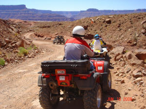
 Our
next riding adventure was in our Silverado 2500 HD Crew Cab. We took the
truck up the Shafer Trail, which is the extension of the Potash Road Trail
that we rode our ATV’s on, into a back entrance to Cayonlands National Park,
past the point where ATV's are allowed. This is a Jeep trail that
switchbacks up the canyon wall and ends at a paved road, at the top of the
canyon inside the national park. After traversing up the canyon, we reached
the top and pavement, and all of us drew a huge breath of relief. Thankfully
we didn't have to go back down. This trail is not for the faint-hearted
or those who have trouble with heights. The trail was very solid and
wasn't very steep, but it was a very narrow shelf that wound its way up
a 1,000 foot elevation change. It was narrow enough that you had to
watch several hundred feet ahead to plan on a wide spot to pull over if
someone was coming the other way. Fortunately, we did not meet any
head on traffic while on the switchbacks. And twice we had to back up to
make it around the turn. Our truck is much longer than a jeep! It was a
tense and exciting journey to the top. All of our kids were very quiet and
concerned during the switchback portion of the ride. But once we arrived
at the top, they decided “that was not so bad now that it’s over”. We asked
them if they wanted to take it back down and they replied with a resounding
“NO!” The next time we go to the Shafer Trail it will be in a Jeep. As much
as we like our truck and ATV’s, we have a new appreciation for Jeeps. Our
next riding adventure was in our Silverado 2500 HD Crew Cab. We took the
truck up the Shafer Trail, which is the extension of the Potash Road Trail
that we rode our ATV’s on, into a back entrance to Cayonlands National Park,
past the point where ATV's are allowed. This is a Jeep trail that
switchbacks up the canyon wall and ends at a paved road, at the top of the
canyon inside the national park. After traversing up the canyon, we reached
the top and pavement, and all of us drew a huge breath of relief. Thankfully
we didn't have to go back down. This trail is not for the faint-hearted
or those who have trouble with heights. The trail was very solid and
wasn't very steep, but it was a very narrow shelf that wound its way up
a 1,000 foot elevation change. It was narrow enough that you had to
watch several hundred feet ahead to plan on a wide spot to pull over if
someone was coming the other way. Fortunately, we did not meet any
head on traffic while on the switchbacks. And twice we had to back up to
make it around the turn. Our truck is much longer than a jeep! It was a
tense and exciting journey to the top. All of our kids were very quiet and
concerned during the switchback portion of the ride. But once we arrived
at the top, they decided “that was not so bad now that it’s over”. We asked
them if they wanted to take it back down and they replied with a resounding
“NO!” The next time we go to the Shafer Trail it will be in a Jeep. As much
as we like our truck and ATV’s, we have a new appreciation for Jeeps.
 The
final day before heading home we hired a guide from High Point Hummer to
take us out in a Hummer. This trek took us to a trail in the Sand Flats
Recreational Area, to a trail called “Hells Revenge”. This trail took us
up and down slick rock fins. Although the fins looked scary enough that
we wouldn't take our truck on them, it felt like a slow moving Disney ride
in the Hummer driven by a professional. The
final day before heading home we hired a guide from High Point Hummer to
take us out in a Hummer. This trek took us to a trail in the Sand Flats
Recreational Area, to a trail called “Hells Revenge”. This trail took us
up and down slick rock fins. Although the fins looked scary enough that
we wouldn't take our truck on them, it felt like a slow moving Disney ride
in the Hummer driven by a professional.
After a week of riding and touring Arches National Park, Canyonlands National
Park, and Dead Horse Point State Park, it was time to head home. All major
mechanicals worked well and we had no flat tires. Round trip, including
driving around Utah was about 3,000 miles. The actual distance from
here to there was a little over 1,300 miles. We’ll always have fond memories
of our 1st trip to Moab. We are looking forward to another grand adventure
someday!
|
| |
| |
 |
|
|
| |
|
|
| |
 |
|
| |
 |
|
| |
 |
|
| |
NEW "Paiute
ATV Trail Guide Book". Page
after page of detailed information on the Paiute
ATV Trails. Photos, Maps, GPS Data for every
intersection and point of interest on the trail,
Tip and Tricks for riding the Paiute ATV Trails.
Click Here for More details. |
|
|
|
 |
|
|
|
 |
|
| |
|
|
|
|
Trails Illustrated topographic maps are designed
to take you into the wilderness and back.
Printed on durable tear-resistant, waterproof
material, this map can go virtually anywhere you
do!
Click here for details. |
|
| |
|
|
|
|
Sponsors
Needed |
|
|
|
Your Ad
Can Go Here! |
|
|
|
Contact Us
Click Here
to request
Details. |
|
|
|
Multiple
Website
Advertising
Special. |
|
|
|
Buy 1 Banner
and |
|
|
|
Get Advertising
on Multiple Websites.
for one low single
ad price. |
|
|
|
| |
|