|
| |
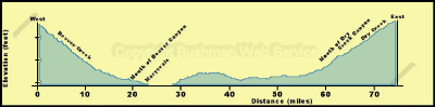
 Marysvale Loop #02
This loop trail is actually two legs going east and west from the
town of Marysvale. These legs each loin the main Paiute ATV Trail, thus
forming the loop.
Approximate Section Time
· Marysvale west to main Paiute Trail -- 0.5 hr
· Marysvale east to main Paiute Trail -- 0.5 hr
The town of Marysvale is located at 5,850 feet elevation. From there
the trail westward rises to 6,000 feet at the mouth of Beaver Creek Canyon
and then to 9,500 feet at the western junction with the main trail. Going
eastward the loop trail descends to 5,832 feet at the crossing of the Sevier
River before rising to 6,800 feet at the mouth of Dry Creek Canyon and 8,924
feet at the eastern junction with the main trail near Dry Creek Guard Station.
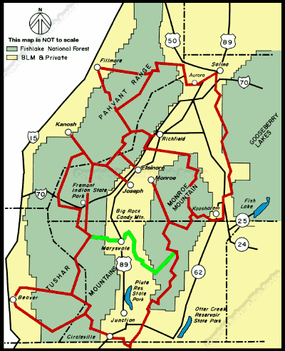
Heading westward out of Marysvale the trail turns north ward at the west
edge of town and heads up Forest Road 113. After a short distance across
sagebrush flats the trail turns west up Beaver Creek. This is a good, weHeading
westward out of Marysvale the trail turns north ward at the west edge of
town and heads up Forest Road 113. After a short distance across sagebrush
flats the trail turns west up Beaver Creek. This is a good, well traveled
road, so be cautious of other traffic. Along the creek bottom, cottonwood
trees and lush vegetation mark the streamside riparian zone. This is an
important area for many animals in this desert environment. A healthy riparian
area also is necessary for delivering clean water to the valleys below.
Pinyon and juniper dot the dry hillsides, but soon give way to spruce and
fir as the main trail is reached at the junction with Forest Road 123.
continued next page
|
| |
 |
|
|
| |
|
|
| |
 |
|
| |
 |
|
| |
 |
|
| |
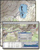
NEW "Paiute
ATV Trail Guide Book". Page
after page of detailed information on the Paiute
ATV Trails. Photos, Maps, GPS Data for every
intersection and point of interest on the trail,
Tip and Tricks for riding the Paiute ATV Trails.
Click Here for More details. |
|
|
|
 |
|
|
|
 |
|
| |
|
|
|
|
Trails Illustrated topographic maps are designed
to take you into the wilderness and back.
Printed on durable tear-resistant, waterproof
material, this map can go virtually anywhere you
do!
Click here for details. |
|
| |
|
|
|
|
Sponsors
Needed |
|
|
|
Your Ad
Can Go Here! |
|
|
|
Contact Us
Click Here
to request
Details. |
|
|
|
Multiple
Website
Advertising
Special. |
|
|
|
Buy 1 Banner
and |
|
|
|
Get Advertising
on Multiple Websites.
for one low single
ad price. |
|
|
|
| |
|