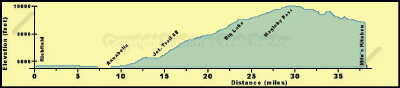
Richfield Side Trail #04
The ride from Richfield to the junction with the Paiute ATV Trail near
Koosharem Guard Station takes about three hours. Intermediate times along
this loop are as follows:
Approximate Section Time
·Richfield to Annabella -------------------------------------
0.75 hr
·Annabella to junction with road 68 ---------------------- 0.25
hr
·Junction of road 68 to Big Lake ------------------------- 0.75
hr
·Big Lake to Magleby Pass ------------------------------- 0.5 hr
·Magleby Pass to Koosharem Guard Station
the junction with the main trail ------------------------ 0.75
hr
From the 5,400 foot elevation of Richfield, this loop rises gently along
the canal before descending to 5,255 feet at the Sevier River crossing.
Then there is a gentle rise to 5,300 feet at Annabella and then 5,995 feet
at the junction with Forest Road 68. From this junction the trail rises
rapidly to 7,400 feet on Bell Rock Ridge. From there it is a gradual assent
to 9,320 feet at Big Lake, and on to the 10,488 foot elevation at Magleby
Pass, the high point of this loop. The trail then descends to 9,070 feet
at the junction with the main Paiute trail.
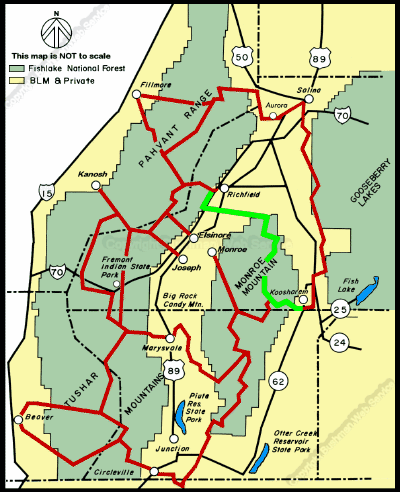
The western leg of the Richfield loop is described on page 6 as the first
segment of the Richfield to Fremont Indian State Park leg.
The eastern leg of this loop also starts on the west edge of Richfield
at the information kiosk. Immediately west of the Interstate 70 bridge the
eastern leg turns left at the first road and heads south along the west
side of I-70. About a mile south of the turn, the trail crosses over a box
culvert that carries the Sevier Valley Canal under the interstate highway.
From there on south to the underpass the trail is along the canal bank road
which is fairly rough. Those traveling north along this loop towards Richfield
should note that you do not leave the side of the canal until you cross
the box culvert.
The canal-bank road passes between two arteries of transportation. On
the east side is I-70 carrying vehicular traffic, while on the west is the
canal carrying the lifeblood of agriculture, here and in the west, where
most of the precipitation occurs as snow in the mountains. Thus, watershed
protection is one of the main concerns of the land managing agencies, such
as the Bureau of Land Management and Forest Service.
continued next page