GENERAL
For each trail section, the description follows the same pattern: 1) Travel
times; 2) A short list of the elevations the trail reaches; and 3) A brief
overview of the trail including general trail conditions, things to be seen,
points of interest, etc. The travel times are based on a moderate rate of
speed that includes stops along the way to view the scenery, take pictures,
make notes, and stretch legs. Undoubtedly some can travel the sections in
shorter times, but they will certainly miss some of the area's scenery.
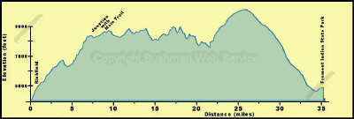
Richfield to Fremont Indian State Park
The ride from Richfield to Fremont Indian State Park,
in Clear Creek Canyon, takes about four hours. Intermediate times for this
portion of the trail are as follows:
Approximate Section Time
· Richfield to junction with main trail 0.5 hr
· Main trail to Second Creek Road 1.5 hrs
· Second Creek Road to Clear Creek Road 0.75 hr
· Clear Creek Road to Fremont Indian State Park 1 hr
From the 5,400 foot elevation of the Sevier River
Valley at Richfield this segment of the Paiute Trail rises to 8,000 feet
along the southern portion of the Pahvant Range before descending to 6,500
f From the 5,400 foot elevation of the Sevier River Valley
at Richfield this segment of the Paiute Trail rises to 8,000 feet along
the southern portion of the Pahvant Range before descending to 6,500 feet
in the valley of Second Creek. The trail then rises to 7,200 feet at the
Second Creek divide with Grass Creek and then ends at Fremont Indian State
Park at 5,800 feet.
The access road from Richfield to the main Paiute ATV Trail follows Forest
Road 096 known locally as the CC road because it was built by the Civilian
Conservation Corps. This is side loop 04 of the Paiute ATV Trail. The road
rises through red rock formations that nature has sculptured into fantastic
shapes and small caves. Along the road there are many panoramic views of
the green valley of the Sevier River. The green contrasts with the reds
of the nearby rocks and the dark green pigmy forests of pinyon and juniper.
This road can be rough, especially after flash floods that wash debris over
the road. Otherwise, it is intermediate-to-easy riding.
Turning south from the Richfield side loop, the main trail follows a
good, rolling dirt road through woodlands of oak, maple, mahogany, pinyon,
and juniper. These woodlands are interspersed with grass and sage meadows
that have been recreated by chaining the woodlands and reseeding with grasses.
South of the side road leading east down Albinus Canyon to Elsinore the
trail is good, but slightly steeper. This is caused by a change in the underlying
rocks to volcanic's from the Tushar Mountains. Vegetation along the trail
is mainly oak brush with conifers in the bottoms. Openings along the trail
provide spectacular views of the deserts in the Great Basin to the west.
In the Great Basin no river reaches the oceans. An opening in the vegetation
on a point west of Cummings Creek gives a great panoramic view.
The trail soon reaches the Second Creek Road (Forest Road 106). This
road allows for some fast travel, but beware of ruts in the road and potential
traffic which can use this road. At the broad, open divide between the Second
Creek and Grass Creek drainages there are spectacular views of the Tushar
Mountains to the south. These are the third highest mountains in Utah and
are snowcapped throughout much of the year. From the divide down to Clear
Creek, the trail passes through an area of intermingled private and National
Forest land that provides pastoral scenery. Three Creeks Reservoir is to
the east.
Crossing Utah Highway 4, the trail parallels this road for a short distance
before heading up Shingle Creek. This short stretch of the trail is slow
going. The trail then follows a good road up Shingle Creek and passes beneath
two massive bridges carrying Interstate 70 high over the creek. The trail
leaves this road at the revegetated pit where they excavated the material
for I-70.
From Shingle Creek to Mill Creek, to the east, the trail follows old
horse trails and roads where grass grows between the wheel tracks. There
are several short, steep pitches along this stretch. Also, the trail crosses
Fish Creek three times. As with the area of Three Creeks, there are grand
views of the Tushar Mountains to the south. Much of the trail is through
woodlands of pinyon and juniper, cleared by chaining in several places.
These clearings permit the rider to compare the closed canopy stands containing
no grass understory with the open grasslands that have been created.
Arriving at the Mill Creek Road (Forest Road 113) the rider can turn
south to follow the main trail, described in the next section, or turn north
to go to Fremont Indian State Park. Fremont Park is about four miles from
the turn onto Mill Creek Road. This road is smooth and provides for fast
travel so be careful of other traffic. The massive Mill Creek bridge for
I-70 and the exotically eroded towers, or hoodoos, near Castle Rock provide
the scenery along this stretch of the trail. Castle Rock Camp ground is
accessible by crossing a bridge and following Forest road 478 for about
a mile. Fremont Indian State Park provides a trailhead as well as an excellent
museum of prehistoric Native American relics.