|
| |
 Welcome
to our Paiute ATV Trail GPS information area. Welcome
to our Paiute ATV Trail GPS information area.
The Piute ATV Trail is really BIG! So it helps if you
can Navigate. That's a fancy way to say "Don't get lost"Believe it or not many
people get lost, or at least they spend a lot of time getting un-lost which can
be frustrating and can basically ruin a great day of riding. At a minimum
it makes for a stressful ride that can drag on late in the day (or into the night)
and might result in serious problems and many concerned people looking for you.
Guess what, a few basic precautions can really help. A GPS is a great tool.
It should not be the only tool you use to navigate. A compass and a
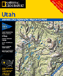
GOOD map are essential. Maps come in lots of
flavors, levels of detail and helpful annotations. Think about how you will
use the map and try to place yourself somewhere on the map to decide if it
the correct level of detail for you. Too much detail can almost be as bad
as too little detail. Juggling a lot of topo quads can be such a pain you
may not actually use them until you are lost, or worse yet you may not take them
with you on a ride because of the bulk.
Here are a few other things you should take
on any ride.
If you have a GPS you can have a great time exploring and finding cool things
on the trail, and just maybe you can get un-lost much more quickly.
GPS related information:
Since loading waypoints into a GPS manually can be tedious and potentially
disastrous (sometimes you don't realize you programmed an "E" waypoint as a "W"
waypoint until you are lost). We have assembled PAIUTE ATV Waypoints and
FREE software for your PC to upload
them to your GPS.
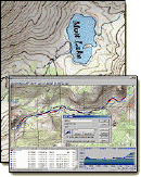
 | Detailed Topographic Maps showing highlighted
ride routes with estimated time and distances, a real help if you want to know if a ride
will last longer than you will. Interesting things to see along
the way with GPS waypoints showing you the route. Now this is information
RICH. |
| Geocaching.
This amounts to a high tech treasure hunt.
Look on the web at

www.geocaching.com to see geocaches within 150 miles of Marysvale to get details on how it works, how to find and place your own Geocache.
Check out our geocache and information
on geocaches on and around the trail. |
GPS and Mapping related links:
|
How Stuff Works - Description of how your GPS works. |
| Maptools.com - GREAT
site for learning about how to use Maps compass and a few basic tools. Lots
of great advice and a few inexpensive and free tools. |
| Sam Wormleys GPS site - WOW, everything you want to know about GPSs.
Need a waypoint? A Map? A Tutorial on how your GPS works? Advice
on which GPS to buy? Want to know what the Russians use for GPS? |
| Joe Mahaffey and Jack Yeazel's GPS web
site . - Everything you EVER
wanted to know concerning GPS's. Go here. |
| Free Topographic maps online. Around
Marysvale , across the
World . Free
is good, but these digital versions of traditional maps lack annotation and can
be difficult to print and use effectively. The net effect is you can be
data rich and information poor. |
| Free Map viewing
software. You'll need this if you download free map data. |
Editorial:
A word on buying a GPS: In the authors humble opinion you do not need to
spend a lot of money on a GPS. GPS's are like VCRs. Every little feature
costs a few dollars more so the first thing to decide is how much $$$ you want to
spend. Many GPSs have mapping features. This might work well but it
should NEVER replace a quality map. At best you are forced to view the map
through a 2" window which makes detail impossible. The type of maps you need
along the Piute ATV trial are Topographic, which means lots of detail and since
the trail covers such a large area and it is quite impossible to "scan" the map
for nearby (or far way) items. At worst you will be highly dependent
on the lifespan of the batteries in your GPS and may find yourself with neither
map nor GPS. The same goes for compass and altimeters. Use your GPS as a GPS,
your compass as a compass and your altimeter as a doorstop. So don't spend
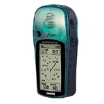
another $100 getting those functions in a GPS. Get a GPS that can store a few recorded
tracks and routes. Personally we like the Garmin Etrex Venture. Stores
plenty of waypoints and tracks. Can track back, sort and categorize waypoints.
Best of all it is small, tough , accurate and easy to learn how to use. The
only reason we like it better than the Garmin Etrex is it can store multiple tracklogs
and routes. Think twice about buying a used older model to save money. Make
sure it has 12 channels. This technology has changes a LOT in the past few
years so unless you can get one for $20, and expect to get $20 of use out of it,
then pass.
|